GRI's Change Detection and Feature Extraction Methods Support Census Bureau Map Updates
June 8, 2005
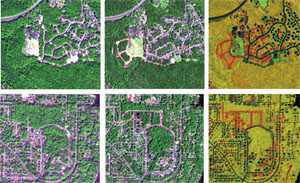
Color views of rural neighborhood areas for early images (left) are contrasted by later images of the same areas (middle). The right column shows unchanged areas in yellow (black in shade), and areas of change are shown in shades of red and green.
From mapping's earliest days, mapmakers have used lines to abstractly depict the centerlines of linear features such as streams and roads. Today, centerline data modernization is an ongoing process in the United States. The U.S Census Bureau is conducting a massive program to modernize its Topologically Integrated Geographic Encoding and Referencing (TIGER) file road centerline data. To complement the bureau's work, the GeoResources Institute (GRI) at Mississippi State University (MSU) is conducting ongoing research in partnership with several commercial companies, including DigitalGlobe, Definiens Imaging, ESRI and Smart Data Strategies. The group's goal is to create technologies and methodologies that detect changes and extract mapaccurate features of interest for updating map products such as centerline files.
See the
full article as it appears in the March/April 2005 edition of the Earth Imaging Journal.
For more information, please contact Chuck O'Hara at
cgohara@GRI.MSState.Edu.
